|
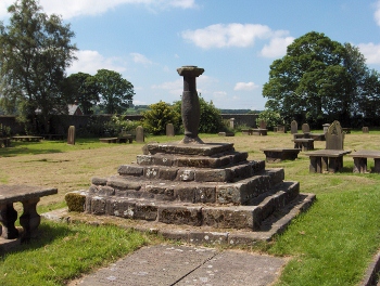
 A. St Wilfrid's church, Ribchester PR3 3XS
B. St Mary's church, Penwortham PR1 0AH
C. St Anne's church, Woodplumpton PR4 0RX
D. Church Street, Churchtown PR3 0HT
E. Pilling Old Church PR3 6HA
F. Williamson Park, Lancaster LA1 1UX
G. Lancaster Priory, Lancaster LA1 1YZ
H. St James the Less church, Tatham LA2 8NH
I. St John's church, Tunstall LA6 2RQ
J. St Michael's church, Whittington LA6 2NT
K. St Alkelda's church, Giggleswick BD24 0BE
L. Martin Top Chapel, Rimington BB7 4EG
M. St Mary C of E church, Whalley BB7 2DG
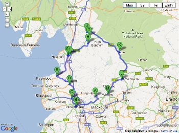
The trail begins in the village of Ribchester, but as it is a circular
route you can begin at any point that is convenient to you or simply
visit a few sundials at a time. For detailed driving instructions please
use Google map: http://goo.gl/maps/43krE
or enter the post code of each destination into a satnav.
 Ribchester:
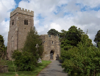
The trail begins in the churchyard of St Wilfrid in the village of Ribchester,
which lies on the banks of the River Ribble. You'll find this sundial
just on your left after you come into the churchyard. The base possibly
dates from the seventeenth century and if you climb the six steps you'll
see that the plate is brass and in the shape of an octagon, though,
sadly, the gnomon is missing. Standing here in the churchyard of St
Wilfrid's you are on the site of a Roman fort - Bremetennacum Veteranorum.
It was built around AD 78 in the reign of the Emperor Vespasian when
Britain was under the governorship of Julius Agricola. Originally built
of timber and turf on a site of five and three quarter acres, it was
rebuilt of stone in around AD 100 and covered the area where the church
and churchyard now stand, although part of it is under the River Ribble
as the flow of the river has altered over the years. Besides the fort
there was also a Romano British village, or Vicus, where the civilians
lived, and the remains of this lie under the modern village. Many artefacts
have been found b Ribchester:
The trail begins in the churchyard of St Wilfrid in the village of Ribchester,
which lies on the banks of the River Ribble. You'll find this sundial
just on your left after you come into the churchyard. The base possibly
dates from the seventeenth century and if you climb the six steps you'll
see that the plate is brass and in the shape of an octagon, though,
sadly, the gnomon is missing. Standing here in the churchyard of St
Wilfrid's you are on the site of a Roman fort - Bremetennacum Veteranorum.
It was built around AD 78 in the reign of the Emperor Vespasian when
Britain was under the governorship of Julius Agricola. Originally built
of timber and turf on a site of five and three quarter acres, it was
rebuilt of stone in around AD 100 and covered the area where the church
and churchyard now stand, although part of it is under the River Ribble
as the flow of the river has altered over the years. Besides the fort
there was also a Romano British village, or Vicus, where the civilians
lived, and the remains of this lie under the modern village. Many artefacts
have been found b
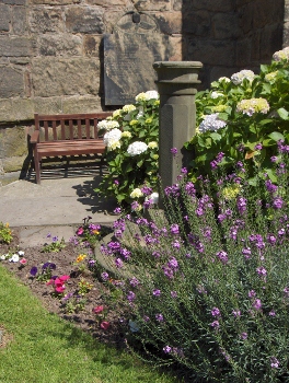 Penwortham:
The sundial can be found outside the porch of the church of St Mary,
just three metres from the south tower. It is made of stone and previously
had a brass plate and gnomon made from cast openwork. The plate is recorded
as being engraved "T. Pritt Fecit" and a date of 1815 with the names
of J. Pemberton, T. Holme, I. Cliff and D. Moss, churchwardens. However,
a parish history records that the plate and gnomon were removed for
safekeeping to the vestry in 1845, probably when the church was undergoing
major alterations to enlarge it but, sadly, no-one now seems to know
what happened to them. Penwortham:
The sundial can be found outside the porch of the church of St Mary,
just three metres from the south tower. It is made of stone and previously
had a brass plate and gnomon made from cast openwork. The plate is recorded
as being engraved "T. Pritt Fecit" and a date of 1815 with the names
of J. Pemberton, T. Holme, I. Cliff and D. Moss, churchwardens. However,
a parish history records that the plate and gnomon were removed for
safekeeping to the vestry in 1845, probably when the church was undergoing
major alterations to enlarge it but, sadly, no-one now seems to know
what happened to them.
St Mary's is built on the site of the 12th century Penwortham Priory
- an offshoot of Evesham Abbey - and the oldest surviving part of the
present church is the chancel which dates from the fourteenth century.
Just to the north is Castle Hill, the site of a Norman motte and bailey.
This ancient church is open to visitors on Tuesdays and Thursdays and
is well worth visiting. Although in a secluded position it is signposted
from the main road, the A59, near Penwortham Bridge.
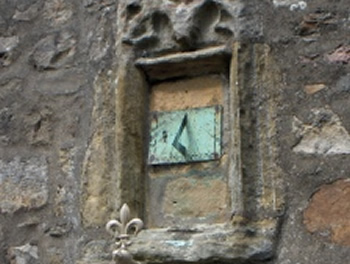
 Woodplumpton:
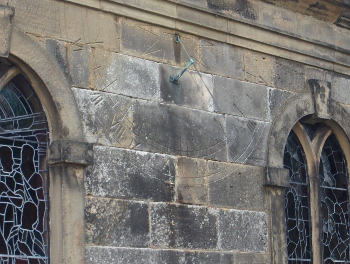
The semi-circular sundial on the church of St Anne is cut into the brickwork
on the south side of the building between the two windows adjacent to
the door. Sundials like this are known as scratch dials or mass dials
as they are often found on churches and were originally used to ensure
that the priest and congregation got to services on time. This one has
the motto: SIC TRANSIT GLORIA MUNDI meaning 'so passes away earthly
glory' incised above it. The gnomon remains so you can still tell the
time, but it is easy to walk past without ever noticing that it's there. Woodplumpton:
The semi-circular sundial on the church of St Anne is cut into the brickwork
on the south side of the building between the two windows adjacent to
the door. Sundials like this are known as scratch dials or mass dials
as they are often found on churches and were originally used to ensure
that the priest and congregation got to services on time. This one has
the motto: SIC TRANSIT GLORIA MUNDI meaning 'so passes away earthly
glory' incised above it. The gnomon remains so you can still tell the
time, but it is easy to walk past without ever noticing that it's there.
There is another sundial in the churchyard, about 20 metres south
of the west end of the church, which is said to date from 1637. It has
a chamfered columnar stone pedestal with a square top, brass plate and
scrolled gnomon.
Another thing to look out for in the churchyard at Woodplumpton is
the witch's grave. Close by the path that leads from the church to the
graveyard you will see a boulder with an inscription on it. It is here
that Meg Shelton is buried. Meg was known locally as a witch and a shape-shifter.
Her real name was Margery Hilton and in 1705 she was found dead in her
cottage, crushed between a barrel and a wall. After her death, because
she had been born a Christian and had never been 'examined as a witch'
it was grudgingly agreed that she had the right to a Christian burial.
She was buried at night, on the 2nd May by torchlight, but reputedly
Meg soon clawed her way back to the surface. She was buried a second
time, but scratched her way out again. So a priest from Cottam Hall
came to exorcise the place where she lay. Afterwards she was re-buried
once more, head down so that if she began to dig again she would only
dig herself deeper in. The grave was topped by a huge boulder, probably
one carried down on a glacier during the Ice Age, to keep her in.
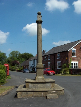
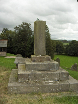
Churchtown: The picturesque little village of Churchtown, just
off the A586, south of Lancaster has a sundial on the south face of
its village cross. The cross is an 18th Century dialpost which was formerly
the village clock. It was restored several years ago by the Churchtown
Society, who had the numerals re-cut and a new pointer installed. There
is also a sundial in the churchyard of St Helen's, around the back of
the church, but the plate and gnomon are missing.
 |
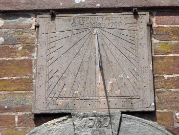 |
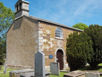
Pilling: The spire of the church at Pilling is easy to find, but if you
go around the back of the church and through a small kissing gate, you
can walk down to Pilling Old Church. Here, above the door you will find
a sundial inscribed: 'Thus ETERNITY approacheth' It is also inscribed:
'G:Holden 1766' and is a memorial to the Rev George Holden who studied
the rise and fall of the tides to calculate the Tide Tables which are
still in use by shipping and fishermen today.
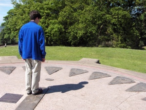 Lancaster:
The Lancaster Sundial can be found in Williamson Park at Lancaster on
the top of the hill near the Ashton Memorial. This was previously the
site of the bandstand, built in 1907, but is now transformed into this
unusual sundial where you yourself become the gnomon, the part that
casts a shadow to tell the time. It is an analemmatic sundial, where
the shadow-casting object is vertical, and is moved depending on the
date. The time is read by seeing where the shadow crosses points laid
out on an ellipse. This is quite different from traditional sundials
where the shadow is cast by a triangular shaped wedge, and no-one knows
who invented this type of sundial, but the French astronomer Lalande
explained the theory behind the analemmatic sundial in 1757. Follow
the instructions on the plaque on top of the Lancaster Sundial so that
you are standing on the correct line for the date and your shadow will
tell you the time by falling across one of the bronze plaques that mark
the daylight hours; each one represents a trade or profession in the
area and they were designed by pupils of Ripley St. Thomas School and
cast by artist Ray Schofield of Sunderland Point. Lancaster:
The Lancaster Sundial can be found in Williamson Park at Lancaster on
the top of the hill near the Ashton Memorial. This was previously the
site of the bandstand, built in 1907, but is now transformed into this
unusual sundial where you yourself become the gnomon, the part that
casts a shadow to tell the time. It is an analemmatic sundial, where
the shadow-casting object is vertical, and is moved depending on the
date. The time is read by seeing where the shadow crosses points laid
out on an ellipse. This is quite different from traditional sundials
where the shadow is cast by a triangular shaped wedge, and no-one knows
who invented this type of sundial, but the French astronomer Lalande
explained the theory behind the analemmatic sundial in 1757. Follow
the instructions on the plaque on top of the Lancaster Sundial so that
you are standing on the correct line for the date and your shadow will
tell you the time by falling across one of the bronze plaques that mark
the daylight hours; each one represents a trade or profession in the
area and they were designed by pupils of Ripley St. Thomas School and
cast by artist Ray Schofield of Sunderland Point.
The sundial, situated at 54.05� North, 2.78� West has been adjusted
for British Summer Time (you will need to take an hour off if you visit
in the winter) and for the correct longitude by maths teacher Peter
Ransom. But there are some small calculations that you must make to
find the 'real' time as opposed to solar time. For example, on the first
of July you need to add four minutes. The calculation is called the
equation of time and there is a graph inscribed into the sundial which
shows the adjustments needed for each day of the year to arrive at the
time as shown on your watch. Remember too that if you visit in the summer
your shadow will be short because the sun is high in the sky and if
it doesn't reach the edge of the dial you will have to imagine where
it would fall if it were longer. In winter, when the sun is lower in
the sky, your shadow will be longer, but at any time of year the length
of your shadow will vary throughout the day.
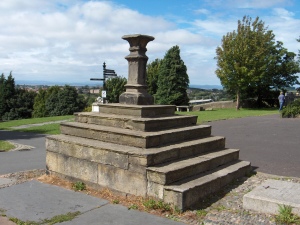 Another sundial,
approximately 15 metres south of the tower, can be found just outside
the main door of the Priory Church of St Mary in the city of Lancaster,
adjacent to Lancaster Castle. It was constructed in the 18th century
and restored in 1894. Built from sandstone it sits on a square base
with a flight of six steps on the east side. The bronze gnomon and dial,
inscribed with Roman numerals and the text: SIC UMBRA VERTIT, SIC VITA
FUGIT 'as the shadow turns so life passes', were removed and stored
after being vandalised. Another sundial,
approximately 15 metres south of the tower, can be found just outside
the main door of the Priory Church of St Mary in the city of Lancaster,
adjacent to Lancaster Castle. It was constructed in the 18th century
and restored in 1894. Built from sandstone it sits on a square base
with a flight of six steps on the east side. The bronze gnomon and dial,
inscribed with Roman numerals and the text: SIC UMBRA VERTIT, SIC VITA
FUGIT 'as the shadow turns so life passes', were removed and stored
after being vandalised.
The Priory Church is built on the site of a Roman Fort and Roman remains
have been found beneath the chancel. Most of what you will see dates
from the 15th century although the Priory was founded in the 11th century
and there has been a church here since 630 AD. The doorway at the west
end of the church appears to be Saxon in origin and in the north aisle
there are some sculptured stones of the same period. It's worth taking
the time to visit and the priory has a small caf� where you might like
to take some light refreshment.
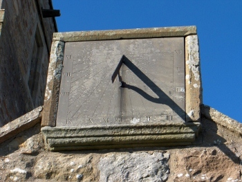
Tatham: This sundial can be found above the porch of the church
of St James the Less at Lower Tatham in the Wenning Valley. At the apex
of the gable is a rectangular slate sundial plate complete with gnomon
which clearly tells the solar time. Lower Tatham is just north of Wray
on the B6480. If you're going to visit the church you will find it down
a narrow lane called Monks Gate, and there is a small signpost which
points to it.
 |
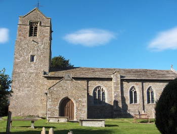 |
There has been a church here since Saxon times and behind the present
altar are the remains of an ancient Saxon stone altar. The church you
see today was mostly built in the 15th century, although there are some
13th century and Norman remains, notably a carved stone coffin lid with
the cross of a Crusader dating from around 1100. The tower was reconstructed
in 1722 and the church was restored during 1885-1887 by the Lancashire
architects Paley and Austen. This was made possible by the generosity
of the Foster family of nearby Hornby Castle and the church features
in the painting of Hornby Castle by JMW Turner.
Tunstall: The sundial above the south porch of the church of
St John the Baptist is dated 1637. It was added after major rebuilding
work on the west tower around 1415, when a window was walled-up. There
is a room above the porch, which would originally have been used as
a schoolroom or meeting room and this is where the Bronte sisters (Maria,
Elizabeth, Charlotte and Emily) would have eaten their Sunday lunch
when they were pupils at the Clergy Daughters' School in nearby Cowan
Bridge; the school was established by the Rev. William Carus Wilson
in 1824 and the Bronte sisters were amongst its first pupils.
 |
 |
On Sundays they would walk the two miles to Tunstall for the Sunday services.
In Jane Eyre, Charlotte Bronte refers to it as Brocklebridge Church. There
is another sundial in the churchyard at Tunstall, but its location has
become rather overgrown by the trees and although in fairly good repair
the plate and gnomon are missing.
 Whittington:
This sundial which can be found on top of a steep slope to the west
of the church has recently been restored and the plate and gnomon are
both in place. The inscription on the plate is hard to decipher but
is said to read: 'Ex dn. Ric. Jackson Rector de Whittington An. Dn.
1641.' The church, which is dedicated to the archangel Michael, stands
on the mound of a Norman motte and bailey castle. It's believed that
there has been a church on this site since about 1200, but the oldest
part of the present church, which is the tower, dates from around the
late 15th century. Whittington:
This sundial which can be found on top of a steep slope to the west
of the church has recently been restored and the plate and gnomon are
both in place. The inscription on the plate is hard to decipher but
is said to read: 'Ex dn. Ric. Jackson Rector de Whittington An. Dn.
1641.' The church, which is dedicated to the archangel Michael, stands
on the mound of a Norman motte and bailey castle. It's believed that
there has been a church on this site since about 1200, but the oldest
part of the present church, which is the tower, dates from around the
late 15th century.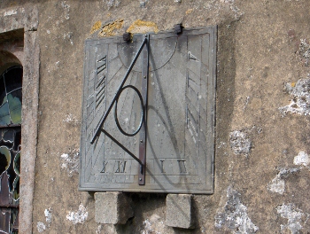
Giggleswick: As you return south it may be worth crossing the
border into Yorkshire to see this sundial on the church of St Alkelda
at Giggleswick. The television personality Russell Harty who lived in
the village and was at one time a teacher at Giggleswick School is buried
in the churchyard here.
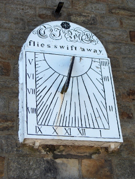 Rimington:
The sundial on the wall of Martin Top Chapel, us that Time Flies Swift
Away. The Salem Congregational Chapel lies above the main village on
Long Lover Lane and is the only place of worship in Rimington. Here
the tune Rimington by local composer Francis Duckworth, is still regularly
heard sung to the hymn Jesus Shall Reign. Rimington:
The sundial on the wall of Martin Top Chapel, us that Time Flies Swift
Away. The Salem Congregational Chapel lies above the main village on
Long Lover Lane and is the only place of worship in Rimington. Here
the tune Rimington by local composer Francis Duckworth, is still regularly
heard sung to the hymn Jesus Shall Reign.
Whalley: The last sundial, which will bring you almost full
circle to your starting point, is in the churchyard at Whalley. The
sundial, made from sandstone, is located to the east of the parish church
of St Mary and All Saints, and is thought to date from 1757. Although
visitors may come to see the ruins of the nearby Abbey, the church is
older and the three ancient Celtic crosses in the churchyard confirm
that an original wooden church was situated here in Saxon times. 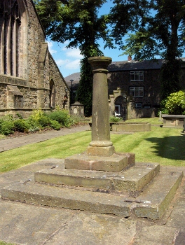 The
present building probably dates from around 1200 A.D., although nowadays
it is the beautifully carved misericord seats in the choir stalls, originally
carved for the Abbey in around 1430, including the one that depicts
a man shoeing a goose, that visitors flock to see. There is another
sundial over the gatehouse of the abbey. This photograph, taken in the
late afternoon on a winter's day, shows the setting sun casting a warm
glow over the ancient stones. Whalley is a busy village and there are
many places here for a good meal at the end of your day. The
present building probably dates from around 1200 A.D., although nowadays
it is the beautifully carved misericord seats in the choir stalls, originally
carved for the Abbey in around 1430, including the one that depicts
a man shoeing a goose, that visitors flock to see. There is another
sundial over the gatehouse of the abbey. This photograph, taken in the
late afternoon on a winter's day, shows the setting sun casting a warm
glow over the ancient stones. Whalley is a busy village and there are
many places here for a good meal at the end of your day. 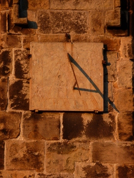
This sundial trail was kindly written by Elizabeth Ashworth for the
2012 Sundial Trails Competition. You can see many more images of Lancashire
sundials on her blog http://lancashiresundials.wordpress.com/
|
 For
a full overview click
here
For
a full overview click
here